
Shelbyville Neighbors by Public Source
Looking up Shelbyville neighbors means comparing records about land, addresses, and public activity. No official source supplies a complete list of who sleeps at each home. The parcel map shows nearby land and may link to an owner card. Tax and deed records add names tied to parcels. Historical directories can show occupants for an earlier year. Each source answers a smaller question about the block.
| Source | What it shows about a block | Access or limit |
|---|---|---|
| WTH GIS | Parcel lines, adjacent cards, and district layers | Free map; inspect each parcel |
| Assessor card | Owner, mailing and situs fields, property data | Free; not a household record |
| Recorder | Recorded parties, legal descriptions, and dates | Doxpop, office terminals, and older books |
| Treasurer | Tax rows by address, parcel, or name | Free search; no block browse |
| Voter file | Precinct or walking-list data if county policy permits | VRG-24 and statutory limits |
| City permits | Projects, inspections, or cases tied to an address | Citizenserve or office; coverage gap |
| Historic sources | Past names, house numbers, and building footprints | Library, State Library, and map collections |
An owner is not always an occupant. A mailing address can belong to a service address or another property. A historical directory name belongs to its publication year. Record the source date and the exact field before describing anyone as a current neighbor.
Map a Shelbyville Block Outward
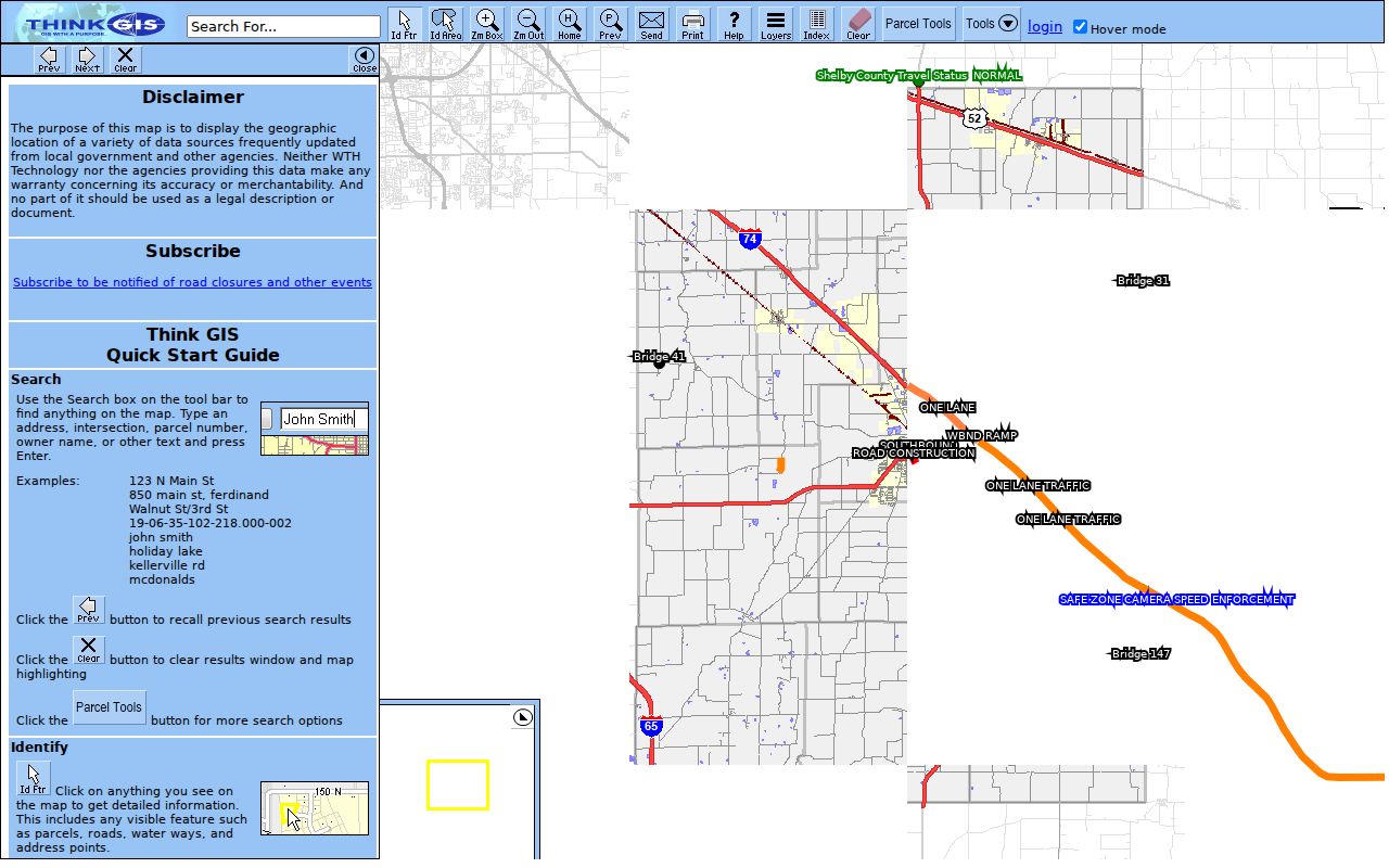
The Shelby County WTH GIS viewer supports a repeatable adjacent-parcel method. It searches text, addresses, intersections, parcel numbers, and owners. Identify & Pan opens a feature, Identify Areas names boundaries containing a point, and the Layers tool supplies roads, parcels, aerial imagery, and available district context.
- Search the subject address and zoom to its parcel. Save the parcel number and map date.
- Click the subject parcel, then each parcel sharing a line or sitting directly across the street.
- Open each linked card. Record owner, situs, mailing address, legal description, transfer date, and parent parcel when shown.
- Mark each result by direction. Note roads, parks, schools, utilities, common tracts, or combined parcels instead of treating all shapes as homes.
- Use Layers and Identify Areas for township, school, flood, zoning, district, or neighborhood context. Treat a layer label as geography, not membership.
- Use Export List to Excel only for output the viewer supplies. It does not create a voter or household list.
This process stays on the immediate radius around one address. For the longer chain along a named road, the Shelbyville street directory carries the search farther.
The county GIS screenshot shows the actual map interface used for this block method. Open the live Shelby County parcel viewer before relying on the image.
Check Shelbyville Neighbor Parcels
After mapping the block, compare each card with the Shelby County XSoft assessment search. Its autocomplete requires at least three characters and searches owner, address, or property number. Suggestions can show a state number, owner, address, and assessed value. Selecting one opens the property result.
Keep situs and mailing addresses apart. Situs means the mapped physical location. Mailing means the address used for tax correspondence. The sample county card has different Shelbyville addresses for those fields. It also includes a parcel number, parent parcel, township, district, school corporation, legal description, transfer table, and building details. None of that proves the owner occupies the parcel.
For a disputed ownership point, use the Recorder's deed and legal description. A map edge may represent a right-of-way, common area, utility tract, or parcel split. Plats and surveys can explain shapes that the street number alone cannot.
Shelbyville Neighbors and Voter Data
Indiana Voters is built for exact individual checks, not an open map of registrants. Its registration form asks for first name, last name, date of birth, and county. Polling-place and ballot tools also allow county, precinct, and split-precinct selection. No public search by arbitrary block or street was exposed.
Indiana law generally permits inspection and copying of voter registration forms subject to exceptions. Computerized data follows a countywide, nondiscriminatory policy. State Form VRG-24 is used for a computerized request and offers countywide, township, precinct, vote-history, voter-registration, and walking-list choices. A completed form and payment go to the county voter office. Shelby County's current fee, file format, and block-level sample were not found.
Confidential material includes full Social Security numbers, certain registration-agency information, citizenship proof, Address Confidentiality Program records, and protected absentee or provisional material. Ballot secrecy remains intact. Do not infer an unlisted household from one voter match.
Note: The Shelby County Election Officer is reached at 317-392-6324 for current request policy and permitted formats.
Shelbyville Community Record Routes
No official Shelbyville neighborhood-association directory, umbrella HOA list, or current block-watch inventory was located. That gap should stay visible. Public institutions can still supply local context, but their records are not proof that a named person lives on the block.
Shelby County Public Library
Genealogy and History holdings include directories, phone books, yearbooks, church files, newspapers, obituaries, and plat maps. Ask by street, name, and year.
Grover Center
The Shelby County Historical Society can add historic photographs, business context, local surnames, and material connected with Streets of Old Shelby.
City public meetings
Common Council, Plan Commission, Board of Zoning Appeals, and Parks notices can identify projects, addresses, appointees, and public comments by date.
St. Joseph and cemetery records
Parish, church, and cemetery sources can support historical family or neighborhood research. The library also keeps church records.
St. Joseph parish and cemetery, 704 Morris Ave
School yearbooks, the library's Omeka archive, newspapers, and public meeting files may connect a street to a civic event or past resident. No public alumni, fraternal, union, or funeral-home-wide roster was found. Ask the relevant repository by organization, surname, and year rather than inferring membership.
Historic Shelbyville Blocks on Sanborn Maps
Sanborn fire-insurance sheets can rebuild a block before modern parcel systems. Shelbyville editions cover 1887, 1893, 1898, 1905, 1910, 1916, and 1926, plus continuations through later years. They show house and block numbers, footprints, materials and uses, street widths, sidewalks, and adjoining boundaries.
Pair the map with a city directory or census from the same period. This can resolve an old number and show whether the neighboring feature was a home, factory, shop, or vacant tract. It is especially useful in Shelbyville's factory-era areas and near old rail geography. The East Side Historic District developed along the former railroad and retains buildings tied to that history.
A historical block is not a current neighbor list. Preserve the map year and directory year, then use the modern parcel map only to test continuity.
Official Shelbyville Rolls and Tools
Commercial neighbor tools may merge names, phone records, and addresses from many dates. That can make the output look broad while hiding where each fact came from. Official records are narrower, but their custodian, date, and field meaning are easier to verify.
| Question | Official record route | Commercial category limit |
|---|---|---|
| Which parcels touch? | WTH GIS map | Boundary source may be unclear |
| Who holds recorded title? | Recorder deed and legal description | Name can be stale or merged |
| What is the tax contact? | Assessor or Treasurer mailing field | May present contact as residence |
| Who lived here in an old year? | Dated directory, census, or obituary | Collection date may be hidden |
Use the smallest record needed for a lawful personal question. Save the source URL and inspection date. If two sources disagree, ask the office that created the record instead of blending the names into one claim.
Privacy for Shelbyville Neighbors
Some people and addresses are protected. Indiana's Address Confidentiality Program can provide an eligible victim with a substitute mailing address. Voter records for participants are confidential. Indiana Code 36-1-8.5 and Shelby County Ordinance O-2016-14 also restrict property-address searches for certain covered people. A missing name may reflect protection, not a vacant parcel.
Utility accounts, delivery records, and private member rosters are not substitutes for public block research. A deed party may have sold, an owner may receive mail elsewhere, and an old directory occupant may have moved. Describe the record, its date, and its limit. Do not label every owner or voter as a present neighbor.
Lawful use. Research Shelbyville neighbors for civic curiosity, reconnection, property context, or personal safety. Never use records to stalk, harass, intimidate, or harm anyone.
A missing owner name or voter match has several possible causes. The parcel may be held by an entity, the tax notice may go to another address, the person may not be registered, or Indiana confidentiality rules may restrict the result. Do not fill that gap with a guess. Save the parcel number and ask the Assessor, Auditor, Recorder, or election office about the public record that actually exists.
For a historical block, date every comparison. A 1910 Sanborn sheet, a directory from a nearby year, and the 1910 census may describe related geography, but they were made for different purposes. Street numbers and household lists may not align. Cite the sheet, page, edition, and census location, then use deeds or plats to bridge the land. This keeps a Shelbyville neighbors search tied to evidence instead of a modern map assumption.